
Going further with the WAGDA Geodatabases
| Once you understand the basics of finding data within the databases, joining the tables to geographic features, and creating thematic maps, there are some additional steps that you may want or need to take. |
| Creating Subsets of Data | ||
| Working With Other Summary Levels |
In some cases, you may want or need to modify the data tables to better suit your purposes. For example, the census breaks data on age down into five-year cohorts by gender. If you wanted to map all persons (male and female) of a particular age group, you would have to modify the data by creating a new field that combines men and women for each age group. This can be accomplished either in ArcMap (by adding a new field in ArcCatalog, and then going into the edit mode in ArcMap and populating that field using a calculation) or in Microsoft Access (by creating a query, creating an expression that will create a new calculated field, saving the query as a make-table query, and running the query to create a new table with the new field - see the Concatenating Cells in Access tutorial for full instructions).
Creating Geographic Subsets of Data
The county-level geodatabases provide all of the data for a particular county. But there may be instances where you might be interested in just a subset of the county. If you are interested in analyzing or mapping census data for a particular city, you can create an extract of the census geography (tracts, block groups, or blocks) for that city using the city boundaries included in the geodatabase. To do this: add the city boundaries and census boundaries to a map, select the city you are interested in (by clicking on it on the map with the select feature tool, or selecting the record(s) in the city boundary attribute table for that city), go to Selection > Select by Location, and select features from the census layer that have their center in the selected features of the city layer (see Figure 1). Once the census features are selected (Figure 2), you can add to or subtract from the selection by going to Selection > Interactive Selection, choosing an option, and then selecting features. Once you have finished making your selection, right click on the census layer in the table of contents and click Data > Export Data, and export the selected features to a new feature class in the geodatabase or to a new shapefile. The end result will be a census geography layer that contains just census geography for a particular city. You can then join census tables from the geodatabase to the new census layer.
|
Figure 1 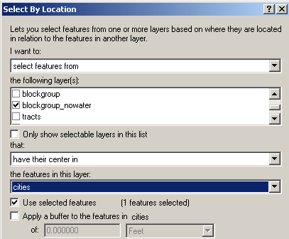 In this example, all of the census block groups that have their geographic center within the City of Kirkland have been selected. This selection can be exported to a new layer, which will only contain the block groups for Kirkland. |
Figure 2 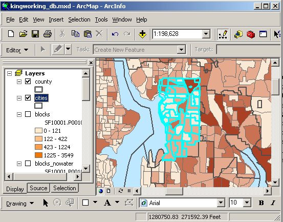 |
If you were interested in creating a subset of census geographies for an area other than cities (such as un-incorporated places or zip codes), you can download these layers through WAGDA or through a repository that WAGDA links to, add the shapefiles to your map, and perform the same operation described above. The State of Washington OFM Geospatial Data Files, the Census Bureau's TIGER/LINE Shapefiles or Cartographic Boundary Files, and ESRI's CensusWatch are all good sources for administrative boundary files.
Working With Other Summary Levels
The geodatabases were constructed to allow users to quickly join and map data at the tract, blockgroup, and block level. However, the county-level geodatabases actually contain data for every geographic level in that county urban areas, county-subdivisions, zip codes, designated places, American Indian reservations, congressional and legislative districts, etc. If you want to map data at one of these geographic levels (rather than mapping census geographies within these layers, as previously described), you could do so by obtaining a geographic boundary file for the level you are interested in and joining it to the census data based on a common field.
Each record in each census data table is uniquely identified by a LOGRECNO field. In all likelihood, other boundary files will not contain this field, but will probably contain a FIPS code or an FID number. Each geodatabase contains a geography table, SF1geo or SF3geo, which contains a number of geographic identifiers, and contains a LOGRECNO field to relate these numbers to the data tables. The geo table also contains a summary level (i.e. geographic level) field that indicates the place level for each record. By manipulating the data using concatenation, relationships, and queries, it is possible to relate the data tables to other geography boundary files, but this process will require some moderate database skills.
Please note that the state-level database does not contain all of the summary level information for the state. Counties, metropolitan areas, places, census tracts, and 5-digit ZIP code tabulation areas are the only levels included.